Hello! Our clients have increasingly expressed interest in the spatial aspects of digitalization. To cater to this demand, we will be regularly posting related content. Our aim is to simplify these complex concepts and open up new avenues through which our clients can benefit. We highly value your feedback and interaction with our posts. This is intended for middle management and project managers. If you happened to miss this post, we encourage you to give it a read!
Implementing GIS Applications: A Scalability Roadmap for Stakeholders
An Exploration of Workflows, GIS Software, Application Areas, and SDI-Considerations for Effective Implementation
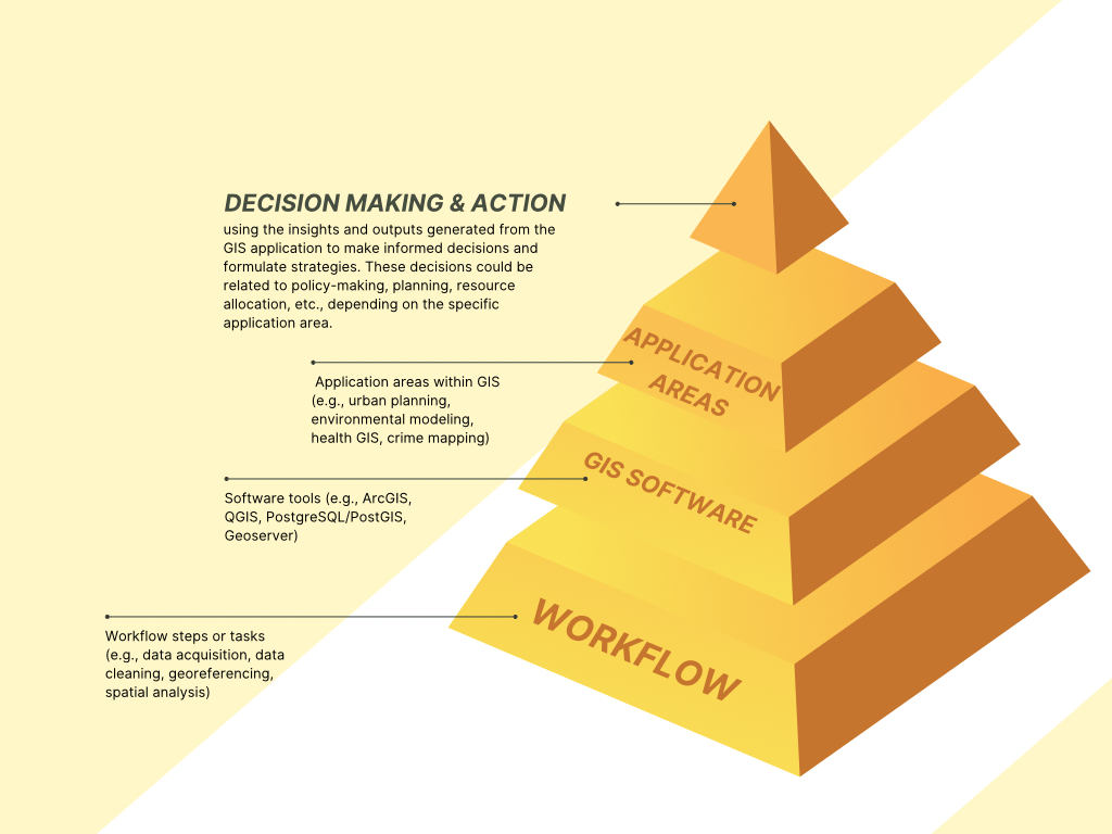
The interplay of Geographic Information System (GIS) components can be conceptualized as a pyramid, with each layer representing a different aspect of the GIS ecosystem. This model of the GIS workflow pyramid can serve as a useful visualization to understand how the various elements interact and support each other in a GIS project. The pyramid comprises three levels: Workflow Steps/Tasks, Software Tools, and Application Areas.
Reading Time: 15 min.
This three-tier pyramid presents a holistic yet differentiated view of the GIS process, reflecting the integral. We find the fundamental GIS workflow steps or tasks at the pyramid's base. These represent the operational procedures that guide any GIS project, forming the cornerstone of the entire system. The next level of the pyramid represents the GIS software tools, pivotal in carrying out the workflow tasks. They provide the necessary functionalities to execute each workflow step and turn data into meaningful outputs. At the pyramid's apex, we find the application areas. This tier represents the specific contexts or fields where GIS finds its use. These real-world scenarios drive the need for geospatial analysis, dictating the project's overall objectives and directing the selection of tasks and tools. Adding a cap at the top of the pyramid could represent integrating and utilizing the GIS findings into decision-making processes or action plans. The "jewel" or pinnacle layer could be labeled "Decision Making & Action" because it uses the insights and outputs generated from the application to make informed decisions and formulate strategies.
Workflow Steps/Tasks: Without fundamental GIS workflow steps, the rest of the pyramid would be baseless, like constructing a building without a solid foundation. These tasks include acquiring and preprocessing geospatial data, from simple digitizing paper maps to complex satellite imagery processing and LiDAR data manipulation. Further steps involve data cleaning, ensuring the quality and consistency of geospatial data, thereby reducing the risk of inaccurate analysis or misleading results. These tasks may also include georeferencing, essential for situating data accurately within geographical space, and data integration, a vital step to merge diverse data types or sources into a comprehensive and coherent dataset. Also in this base tier are the analysis processes, the heart of GIS, transforming raw data into valuable insights. These include spatial and statistical analysis, geostatistics, network analysis, terrain analysis, and temporal or time-series analysis. Depending on the project, this might involve assessing land use patterns, understanding transport networks, predicting flood patterns, and tracking changes in urban growth over time.
Software Tools: The next level of the pyramid tier includes proprietary tools like ArcGIS, known for its robust suite of capabilities, and open-source alternatives such as QGIS and GRASS GIS, which offer flexibility and community-driven innovation. Other specialized tools might include PostgreSQL with PostGIS for spatial database management, Geoserver for data sharing and distribution, or programming languages like Python and R for customized data processing and analysis. Each software tool comes with its strengths and limitations, and its selection often depends on the specific requirements of the tasks, budget constraints, and the technical proficiency of the GIS team. Some might excel in data visualization, while others offer advanced spatial analysis capabilities. The choice of software tools significantly influences the project's efficiency, precision, and overall success.
Application Areas: At the pyramid's apex, we find Application areas within GIS are extremely diverse, spanning nearly every industry and sector. The term "Application Areas" in the context of GIS typically refers to the different domains or fields where GIS technology is applied, such as urban planning, environmental management, transportation, public health, etc. Urban planners might use GIS to analyze land use patterns and infrastructure; environmental scientists might use it to model climate change impacts or manage natural resources; public health officials might use it to understand disease spread patterns; law enforcement agencies might employ GIS for crime mapping and predictive policing. These application areas bring purpose to the GIS workflow, providing not just the end goal but also shaping the questions we ask of our data and the tools and processes we use to answer them. Whether it's mapping deforestation in the Amazon, analyzing traffic flow in a city, tracking the spread of a pandemic, or planning a new subway line, the application area is the driving force behind each GIS project.
GIS-Informed Decision Making: This level will involve using the insights and outputs generated from the GIS application to make informed decisions and formulate strategies. These decisions could be related to policy-making, planning, resource allocation, etc., depending on the specific application area of the GIS project. For example, in an urban planning context, this could involve using the GIS analysis to decide on the locations for new infrastructure development. This could involve using the GIS outputs to formulate conservation strategies in an environmental management context. Including this layer emphasizes the ultimate goal of most GIS projects, which is not merely to generate maps or perform analyses but to provide actionable insights that can help solve real-world problems or inform important decisions. This top layer could also include an evaluation component, where the decisions' or actions' effectiveness and impact are assessed, potentially leading to a new round of GIS analysis. This evaluation would feed the system, creating a continuous improvement cycle. This cyclical process is sometimes depicted as a separate feedback loop or a spiral rather than a pyramid.
Designing and implementing a GIS project involves multiple challenges, each with unique difficulties and demands. The three main components of workflow, tool, and application require different skills, resources, and expert-making processes. The complexity of each phase may vary based on the project's scope, the team's skills and knowledge, the availability of resources, and the specific requirements of the application area. GIS software often has steep learning curves, requiring time and effort to become proficient. This can be especially challenging in environments with limited training and professional development resources.
Constructing the Workflow: This requires a deep understanding of the project's objectives, the data requirements, and the sequence of operations needed to transform raw data into meaningful information. Defining the workflow involves specifying the tasks to be performed, their order, the inputs and outputs of each task, and the dependencies between tasks. A challenging aspect is ensuring that the workflow is robust and efficient. This requires understanding the computational complexities of different tasks and designing the workflow to optimize the use of resources. For example, in a project involving the processing of large volumes of remote sensing data, the workflow needs to be designed to minimize data redundancy and ensure efficient use of storage and computational resources. Constructing the workflow also involves data management and organization decisions, such as the structuring of databases, the design of data schemas, and the development of metadata standards. These decisions can have long-term implications for the maintainability and scalability of the GIS project.
Using the GIS Tool: The tools provide the functionalities needed to execute the tasks specified in the workflow, and their effective use is critical for the project's success. One challenge is the selection of the right tool for each task. With many proprietary and open-source GIS software available, each with its strengths and weaknesses, choosing the best one can be daunting. For instance, while ArcGIS offers advanced analysis capabilities and a polished user interface, it is costly. On the other hand, QGIS is free and has a robust set of features, but it may not provide the same level of customer support as ArcGIS. Another challenge is mastering the use of the chosen tool. Finally, given the rapidly evolving nature of GIS technology, keeping up-to-date with new tools, functionalities, and best practices can be a challenge.
Designing the Application: The design of the GIS application is often the most visible and impactful part of a GIS project, but it can also be the most challenging. One major challenge is ensuring that the application meets the needs of the end-users. This requires a deep understanding of the users' requirements, other workflows, and challenges. For example, if the application is designed for urban planners, it should provide functionalities for analyzing land use patterns, estimating population densities, and predicting the impacts of urban development. The tools and functionalities provided by general-purpose GIS software (like ArcGIS, QGIS, etc.) can often be directly used in various application areas. For instance, the same spatial analysis tools could be used to study the spatial patterns of crime in a city (public safety), to model the spread of a disease, or to analyze the impacts of land-use change. However, each application area's specific needs and requirements might sometimes necessitate the development of specialized GIS applications. These could be built as extensions or plugins to the general-purpose GIS software or standalone applications that use GIS libraries and frameworks. For instance, a GIS tool developed specifically for transportation planning might include sophisticated traffic simulation capabilities, which are not typically found in general-purpose GIS software. Whether to use a general-purpose GIS tool directly or develop a specialized application often depends on the complexity and specificity of the tasks required in the application area. The tools provided by general-purpose GIS software might suffice for simple to moderately complex tasks. However, a custom-built GIS application might be necessary for complex or highly specialized tasks. For a specialized GIS application, designing the interface of the application is another challenge. The interface should be intuitive and user-friendly, making it easy for users to perform tasks and interpret the results. Poorly designed interfaces can lead to user frustration and lower application adoption. The performance of the application is another critical aspect. The application should be able to handle large volumes of data and perform complex analyses efficiently. This requires careful design of the data structures and algorithms used in the application. Finally, the design of the application should take into account future scalability.
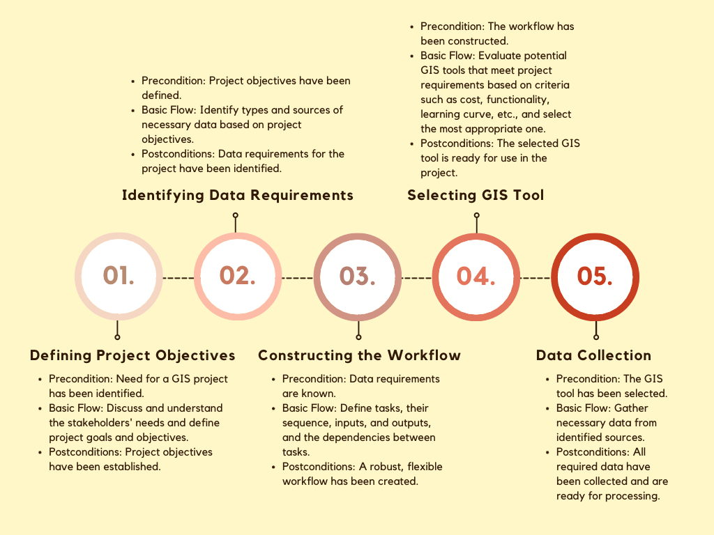
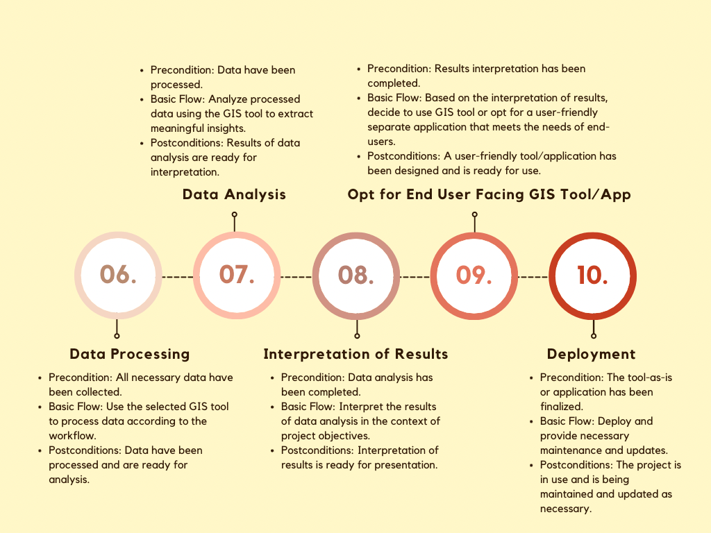
This ten-step flow diagram shown above and below represents a systematic approach to managing a GIS project, provides a framework to guide project implementation from inception to completion, and encapsulates key stages such as defining project objectives, constructing the workflow, selecting the GIS tool, collecting and processing data, interpreting results, and ultimately designing and deploying the application. It aids in aligning problem understanding, a roadmap for the project, and diverse stakeholders, including project managers, GIS analysts, software developers, and others involved in executing the GIS project. It is a blueprint for developing a GIS application to address a problem, facilitate identifying tasks, allocate resources, and construct a timeline.
The flowchart highlights important decision points, such as choosing a GIS tool and deciding between using the GIS tool's direct output or a specialized application. Even though it's unusual in the GIS field, the flowchart is described using a "use case" concept commonly found in software development and system analysis. This involves preconditions (requirements that must be met before the use case begins), main flow (a sequence of interactions between users and the system to achieve a desired outcome), and postconditions (the state after the use case is completed). The reason for this unconventional approach is to aid understanding. The use case concept provides a clear, structured framework for describing complex workflows, even if it's not typically used in GIS. However, it's worth noting that, unlike other software domains, GIS usually doesn't require detailed use case descriptions. A well-defined problem and workflow often eliminate the need for explicit use cases since GIS typically involves specific tasks and workflows inherent to spatial analysis and geospatial data processing. Instead of traditional use cases, GIS professionals rely on established workflows and best practices specific to the field. These workflows provide step-by-step instructions for performing common GIS tasks, such as data acquisition, preprocessing, analysis, and visualization. Following these established workflows allows users to achieve their goals without needing explicitly defined use cases. In some instances, use cases may be necessary, such as when dealing with complex or custom GIS applications. Specific user interactions and system behaviors must be clearly defined in these cases.
Based on this flowchart, we have developed a comprehensive worksheet that we use with clients to guide the development of GIS applications—it covers the ten components discussed in the diagram. Still, it adds at least three more considerations: open-source GIS software, ISO standards, and an INSPIRE-like framework consideration.
Emphasis on open-source GIS software: We prioritize using open-source GIS software in our workflow. To ensure its practicality and compatibility, we analyze each step twice. First, we discuss it conceptually and then verify its feasibility using open-source tools. This approach enables us to evaluate the difficulty level and explore alternative options.
Adoption of ISO 19115 standards: We strongly advocate adopting ISO 19115 standards. These standards enhance interoperability, data discovery, understanding, sharing, integration, preservation, and compliance. By adhering to these standards, especially when collaborating across institutions, we can ensure seamless data integration and effective data management.
Integration into an INSPIRE-like framework: We promote the idea that the GIS application being developed could eventually become part of an INSPIRE-like framework. INSPIRE stands for Infrastructure for Spatial Information in Europe, an initiative by the European Union to establish a harmonized framework for sharing and exchanging spatial data across member states. This framework aims to facilitate the interoperable use of compatibility and compliance with Spatial Data Infrastructure (SDI)— the technological, organizational, and institutional framework for managing and sharing geospatial data. SDI provides the infrastructure and policies necessary to discover, access, integrate, and use spatial data from multiple sources. It facilitates the coordination and cooperation between different stakeholders involved in spatial data management and helps establish standards and protocols for data interoperability. INSPIRE integrates several standards to facilitate harmonized spatial data sharing and exchange. Some examples of these standards include:
INSPIRE Data Specifications: INSPIRE defines a set of data specifications for specific themes such as transport, land use, hydrography, and more. These specifications provide detailed requirements and guidelines for data structure, attributes, and formats, ensuring consistency and interoperability across different data sources. Let's dig deeper into five examples of data specifications defined by INSPIRE. Firstly, INSPIRE establishes a specification for geographical names, ensuring consistent and standardized naming conventions for geographic features. Secondly, it provides a data specification for cadastral parcels, ensuring that information about land ownership and boundaries is consistently represented. Thirdly, INSPIRE defines a specification for transport networks, enabling seamless integration and interoperability of transportation-related data. Fourthly, it establishes a data specification for environmental monitoring facilities, facilitating the sharing and analysis of environmental data. Lastly, INSPIRE provides a specification for land use and land cover, categorizing and describing different types of land use for easy comparison and integration. These data specifications ensure harmonization and interoperability across different themes and domains, enhancing geospatial data sharing, access, and utilization across European member states.
OGC Standards: The Open Geospatial Consortium (OGC) standards are widely used in the geospatial domain and are integrated into INSPIRE. For instance, INSPIRE utilizes the Web Map Service (WMS) and Web Feature Service (WFS) standards for sharing map images and vector data. Using OGC standards allows for seamless data exchange and interoperability between different systems. An SDI is like a big gathering space where people bring all their maps and location information to share with others. It could be government agencies, companies, or even individuals with useful map data. To make it easier for everyone to share their maps at this gathering, OGC created rules that allow a common language that all the maps and systems understand. It's like having a standard way of talking and sharing information ‘between maps.’ WMS allows maps to be shared as pictures, so you can see them online. WFS allows more detailed information about maps to be shared, like the names of streets or the locations of specific places.
INSPIRE Network Services: INSPIRE defines specific network services to enable the discovery, view, and download of spatial data. These services include the INSPIRE Discovery Service, INSPIRE View Service, INSPIRE Download Service, and INSPIRE Transformation Service. Each service adheres to relevant standards to ensure compatibility and facilitate data access and utilization. The INSPIRE Discovery Service is responsible for helping users find and discover relevant spatial data. It allows users to search for specific datasets, services, or resources based on various criteria, such as keywords, geographic extent, or thematic categories. The Discovery Service provides metadata about available data resources, helping users assess their suitability and understand the content and quality of the data. The INSPIRE View Service allows users to visualize and explore spatial data in a standardized and interoperable way. It provides a means to access and display map images or other geospatial information through web-based applications. The View Service adheres to standard protocols and formats, ensuring compatibility across different systems and enabling users to view and interact with spatial data seamlessly. The INSPIRE Download Service allows users to retrieve and download specific datasets or portions of spatial data. This service enables users to access the actual data in a machine-readable format, such as a file or a database, for further analysis or integration into their own applications. The Download Service follows standardized protocols and data formats to ensure compatibility and facilitate smooth data exchange. The INSPIRE Transformation Service focuses on transforming or converting spatial data from one format or coordinate reference system to another. It helps overcome interoperability challenges due to differences in data structures or spatial reference systems. The Transformation Service provides tools and methods to harmonize and align spatial data, ensuring seamless integration and compatibility between different datasets.
Geospatial Metadata Standards: In addition to ISO 19115, INSPIRE incorporates other geospatial metadata standards such as ISO 19119 (Services Metadata) and ISO 19139 (Metadata XML schema). These standards provide a comprehensive framework for describing spatial data resources, services, and associated metadata, supporting effective data discovery and understanding. ISO 19119 specifically focuses on metadata for geospatial services. It provides guidelines for documenting information about geospatial services, such as map servers or data download services, including details about their capabilities, data formats, and access methods. By incorporating ISO 19119, INSPIRE ensures that the metadata associated with geospatial services is well-documented and easily discoverable. ISO 19139, on the other hand, defines an XML schema for encoding metadata. It provides a standardized format and structure for representing metadata using XML, making it easier to exchange and share metadata across different systems and platforms. INSPIRE utilizes ISO 19139 as part of its metadata framework, ensuring that it conforms to a well-defined structure supporting effective data discovery and understanding. By incorporating these additional geospatial metadata standards, INSPIRE enhances its ability to capture and communicate essential information about spatial data resources, services, and their associated metadata. This comprehensive metadata framework facilitates the discovery, evaluation, and use of geospatial data by providing structured, standardized information that promotes interoperability and effective decision-making.
Coordinate Reference Systems: INSPIRE adopts standards for coordinate reference systems; just a few examples, it adopts three important international coordinate reference systems to ensure compatibility and harmonization of geospatial data. First is the World Geodetic System 1984 (WGS84), a widely used global reference system that serves as a foundation for positioning and mapping applications worldwide. Second, the International Terrestrial Reference Frame (ITRF) is adopted, a globally recognized reference system offering stability and accuracy for precise geodetic measurements. These coordinate reference systems enable consistent spatial referencing, cross-border data sharing, and effective analysis, supporting the interoperable use of geospatial data within the INSPIRE framework.
INSPIRE establishes a coherent framework for interoperating spatial data by integrating these standards. However, it is important to note that applying INSPIRE beyond European states without adaptation and customization would be imprudent. Instead, we should carefully consider a country's specific needs and contexts to adapt INSPIRE principles for successful implementation effectively. The principles stay valid, but adaptation ensures compatibility with existing data infrastructures, technical preferences, and local requirements. INSPIRE ‘inspires’ any state, developed or developing, to enhance data sharing, interoperability, and utilization, but it is not a take-as-fit-all solution.
Let’s look at Africa and brainstorm how INSPIRE should adapt to fit local contexts and realities. These five technical examples highlight possible adaptations and enhancements to INSPIRE to better align with African countries' technical realities and preferences.
Thematic Data Focus: INSPIRE emphasizes specific themes relevant to European member states. The thematic focus could include priorities and challenges specific to the African context to apply INSPIRE in Africa. This may involve incorporating themes such as biodiversity conservation, natural resource management, climate change adaptation, rural development, and infrastructure planning to address African countries' unique needs and priorities.
Coordinate Reference Systems (CRS): INSPIRE relies on specific coordinate reference systems that may not be widely used in Africa. INSPIRE could include additional coordinate reference systems commonly employed in African countries to align with local practices. This could involve incorporating regional or national CRS definitions to ensure seamless integration with existing data sources and systems.
Data Exchange Formats: INSPIRE predominantly uses XML-based formats. Support for additional data exchange formats such as GeoJSON, CSV, or Shapefile could be included to accommodate different data exchange preferences in Africa. This would facilitate easier data sharing and interoperability with existing systems.
Mobile Data Collection: INSPIRE could integrate mobile data collection tools and standards, enabling field data collection using smartphones or tablets. This would empower local communities and field workers to contribute geospatial data, enhancing data coverage and accuracy.
Integration of OpenStreetMap: INSPIRE could promote the integration of OpenStreetMap (OSM) data as a valuable additional data source. This would enhance the availability of detailed and up-to-date geospatial information, particularly in areas where official datasets may be limited.
This article serves as an introductory primer for decision-makers across various sectors and industries where the concepts of Geographic Information System (GIS), Workflows, Open-Source Software, Application Areas, and Spatial Data Infrastructure (SDI) may not be distinctly understood. We strive to present a concise yet comprehensive overview that is not overly complex yet provides illuminating insights into infrastructures, applications, and use cases we often advocate in our solution delivery. OHK often uses GIS and SDI in its planning and analytics work; contact us if you want to learn more about this work.

