
Monday 05.11.20

OHK’s Smart Urban and Transport Analytics Toolbox Articulates Leading Innovative Revitalization Planning in Five City Centers Worldwide
OHK implements a spatial reform model for our clients of town planners, policymakers, municipal administrators, and real estate investors to analyze urban spaces, support smart mobility behaviors and generate sustainability by preserving our built environments' heritage and urban values. We support a systems-thinking view to describe the complexity of key relationships between factors affecting urban dynamics—how a city interacts with its users and how they interact back.
A toolbox is used in planning and re-planning initiatives and piloted in Budapest’s Pest, Cairo’s Khedivial Cairo, France’s Palais Bourbon, Jerusalem’s Old City, and Amman’s Jabal Amman. This blog post illustrates such case studies and offers Insights from years of OHK’s work in urban transport and mobility systems.
From Tahrir Square to Pest to Eiffel, our studies demonstrate metrics never considered in these urban hubs. Daily flows into Cairo’s Tahrir Square exceed 250,000 non-resident persons a day on average, the largest of any public space in a Mideast city, versus only 20,000 local residents in its Downtown vicinity. Paris’s Palais-Bourbon, home to the tour Eiffel, experiences pedestrian and cyclist traffic increases during tourist seasons by a staggering 600% and 120%, respectively, while vehicular traffic rises only by a range of 35-50%.
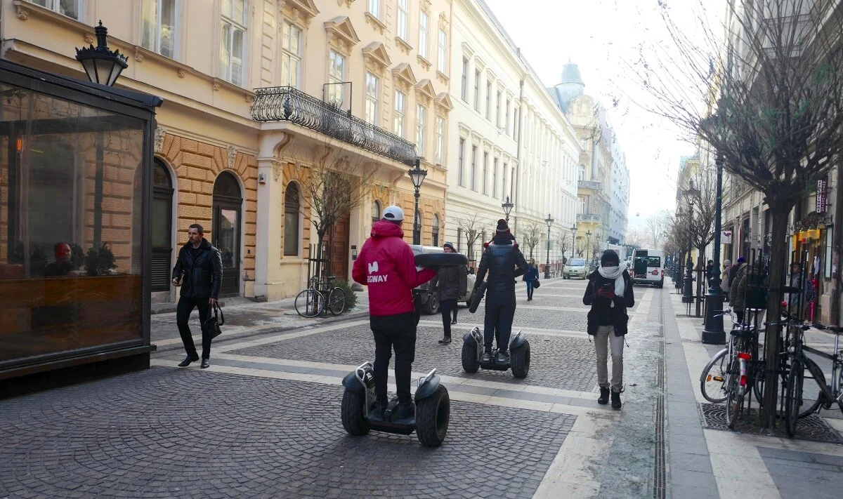
Budapest, the seventh-largest city in the European Union with a population of just under 1.8 million, has been witnessing an urban revival in its major historic neighborhoods. A three-year pilot (2016-2019) was implemented in the area surrounding the St. Stephen's Basilica located in the heart of Pest, the eastern city Danube Riverbank, and one of the most pedestrian-heavy historic centers in all of Hungary. Studying the effect of pedestrianization and the city’s Bubi public bike-sharing system on non-tourism movements was conducted in the shoulder seasons from March to May and September through November. Year-on-year, pedestrian traffic increased by a range of 5%-7%, and cyclists traffic increased by a range of 15%-20%. Photo © OHK Consultants.
Public transport is playing an increasingly vital role in everyone’s lives. It has a critical impact on the competitiveness of both cities and the industries within and around them, it delivers people to work, connects urban fabric, and is the main connective tissue of a civic society.
A government’s role in public transport is critical and foundational because it sets policy, determines the standards of safety and design, provides funding for substantial parts of national infrastructure, and franchises and regulates service delivery. These different areas of responsibilities provide the basis for the delivery of transport services by a range of public, service, and commercial organizations, and without them, cities and their connective mesh of regions cannot economically flourish.
The governance, management, and delivery of a reliable, safe, secure, and efficient transport-mobility system in historic and old cities to serve urban revitalization are different in practice to the planning schemes of new urban areas. The former must respond efficiently to existing needs and living legacies of individuals and businesses whilst safeguarding the built environments. This is a major challenge given the intricacies of human-building relationships which dictate the problem boundaries and solution limitations. OHK has led innovation at this intersection of urban regeneration and smart transport solutions in many places that have only started to deal with such complexity. Over many years, we have worked with governments to help realize policy initiatives that are grounded in a conception of solutions through their development and justification, to their ultimate delivery.
One of the biggest challenges in developing policy is 'designing in' the evaluation of different ideas in regeneration schemes. Too often, this is not considered until after the policy has been implemented, when it may be too late to evaluate whether or not the planned benefits can be or have been realized in practice. Many regeneration schemes fail because they have not asked the right questions about transport and made their answers key to planning and evaluation. In our experience, this is an integral part of policy development at the very early stages of urban regeneration considerations.
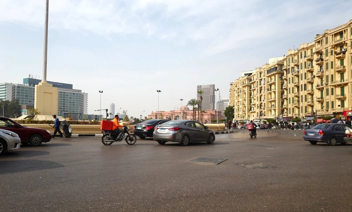
Tahrir Square, Khedivial Cairo’s major public town square and one of Egypt’s urban and historic icons, is undergoing works to reinvigorate public space and movement. It is one of the country’s most congested urban spaces for public transport, vehicular movement, and pedestrians. OHK’s urban regeneration plan of Historic Cairo (2016-2018) supported a 15-months pilot of the first traffic study in Cairo’s center since the 1980s, and the first pedestrian study in Cairo’s urban history—both considered two of the largest schemes of movement measurements ever conducted in Egypt or old cities of the Mideast. The study concluded that daily flows into Cairo’s downtown area exceed 250,000 persons a day on average, the largest of any city in the Mideast. This effort was funded by the European Bank for Reconstruction and Development (EBRD). Photo © OHK Consultants.
As part of our policy and planning efforts, OHK has expertise in a range of technologies to measure movement from baselining to varied scenarios of transport and mobility solutions. Many such technologies are costly, require complex logistics, and do not fit into the spatial planning 'asks' of a robust urban regeneration plan. Most imperatively, the need for a data-rich, quickly-mobilized, low-cost, user-friendly, and well-streamlined set of tools that can be shared, synced and applied to traditional planning approaches useable by our clients.
Understanding traffic and pedestrian congestion stands out as one of the key elements of such ‘tooling’ for regeneration planning needs. How congestion affects our movement is worsening worldwide and no more evident than in old-economy cities, historic centers, heritage towns, and tourist hotspots. The pace at which it negatively affects the built environment, quality of life, and ability to realize heritage conservation is understated in most of the regions OHK has worked. A study we conducted estimates that urban traffic congestion costs the countries of the five pilots in this blog post nearly $35 US Billion every year, and at a rate between 1%-3% of their annual GDP. We also found that in the five pilot cities referenced herewith, in general, travel times increase by a factor of 3 to 7, and carbon dioxide (CO2) emissions rise by a range of 80%-150%.
Building smart cities of the future in especially fragile areas—OHK’s definition of fragility is an immediate or short-term livelihood sensitivity to regeneration efforts, threats to heritage values or pre-existing patterns of land use and people movement that have caused congestion and livelihoods to become one urban reality—can not only be a result of sweeping changes that implement large infrastructure schemes, transport strategies, or innovative traffic management technology. OHK’s approach has always explored first a phased approach of traffic-oriented micro-interventions strategically focused on impact locations and ‘pain areas’ combined with in situ urban re-planning interventions that reexamine land use, control and motivate the users through pattern-changing policy instruments.

Paris’s 7th arrondissement, the Palais-Bourbon, is a pedestrian haven given its international tourist attractions such as the Eiffel Tower and the world-leading museums of Musée d'Orsay and Musée Rodin. This pilot study (2018) evaluated pedestrian and cyclist movement versus vehicular traffic in the tourist high season (June through mid-September, Mid-to-late December) versus other months and found that despite the density of tourists during the summer months and locals and visitors increased shopping and seasonal activities in December, vehicular activity only increases by a range of 35-50% in public squares and intersections while pedestrians and cyclists increase by a staggering 600% and 120%, respectively. Photo © OHK Consultants.
This is where OHK’s toolbox comes into play because it supports a quants-based holistic view. It allows a policy strategist insight into the implications behind the configuration of movement, and enables a planner to read the main parameters of urban spaces that govern the relationships between a site or group of sites, their built environments, and circuits. With our technology experience in developing tools used in urban planning studies and regeneration evaluations, we emphasize a outcome-based focus, asking where and what to measure and what value can that add. OHK’s end-game underscores a sized approach; namely, how directing small to medium and, eventually, larger interventions can address challenging traffic and movement issues timely and cost-effectively.
The toolbox is, in reality, a few tools used together, each applying a certain technique and technology. Central to the components of our tools are the use of software and applications to complement and add value to the approach. OHK’s toolbox is, therefore ‘highly innovative from a technical and urban modeling point of view, yet achieves recommendations quickly’ as one of our clients expresses.
First, we usually produce a space model that emulates the built environment in the area-of-interest. This identifies and accurately measures buildings, infrastructure, and other built environment features through a Digital Surface Model (DSM) representing the XYZs associated with the surface of the urban area including topography and all-natural or human-made features.
In many urban places especially those that fall in developing countries or UNESCO heritage areas, little or no local source data are available to populate analytical models, As a result, in our toolbox, we overcome that through a detailed satellite-based model using stereoscopy, and use satellite sensors from IKONOS, SPOT-5, WorldView, and Terra-ASTER depending on the quality, time horizon and scale of our focus. Once the model is built, it is calibrated a rapid local survey using GPS control in the field. Secondly, Three Dimensional (3D) modeling in a Geographic Information Systems (GIS) application is used to visualize the study area.
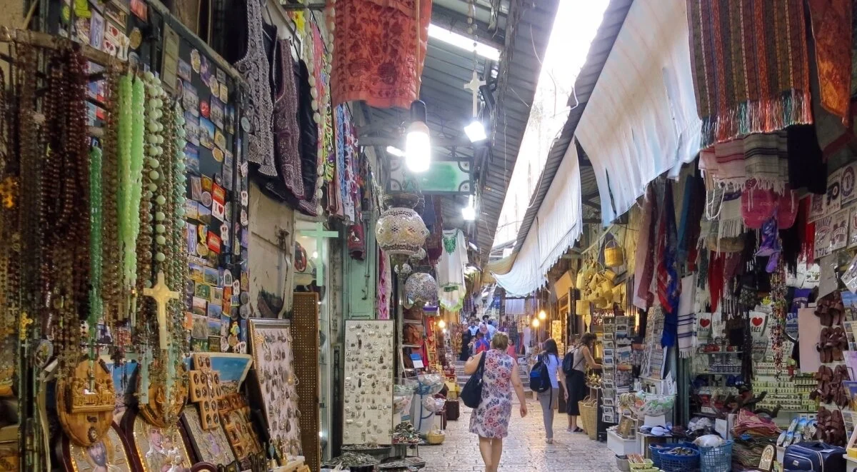
The 1,500 years old, roughly 1-square-kilometer Old City of Jerusalem is a highly visited religious center in the Middle East. It includes the al-Aqsa Mosque, the Temple Mount, and the Church of the Holy Sepulcher and is a UNESCO World Heritage Site since 1981. The pilot was implemented over one year (2015) and was the first pedestrian study in the history of old Jerusalem. Under a regeneration scheme to convert a portfolio of 200 plus Vatican City State buildings from residential to mixed-use, the purpose of the study was to evaluate the buildings’ best-use and optimal locations for adaptive reuse based on pedestrian circuits and current flows. A GIS model for the buildings and pedestrian flows was constructed and run through an optimization algorithm for site, routing, and location selection. This effort was funded by the Vatican, the UN-Habitat, and the European Union. Photo © OHK Consultants.
The third step involves the creation of a detailed urban digital model of the area and the reconstruction of buildings, landscape, and city settings in a language relevant to urban and traffic planning. A tool like Esri’s CityEngine can offer a detailed urban and architectural object visualization, placement, and arrangement. The next step is the introduction of a land-use model sourced from a combination of existing land use maps, google data, and field observations. This takes us many steps further into adding layers of types of data to represent not just the form of places but the use and behaviors. At this stage, traffic and flow measurement points are determined along the main circuits and routes identified while considering land-use patterns and user-centric observations in the field.
Fifthly, a tool running on iOS mobile devices, developed by OHK, is used in the field by a team of surveyors to harvest data on movement in the public street system. They are later aggregated into a single traffic volume, source, and flow model. A step of superimposing various data layers on the 3D model follows and involves analyses to look at traffic levels, movement, and circulation, as well as possible scenarios of different and scale-varied interventions.
Seventh, we may build an economic model of the area under study through combing an algorithm that converts horizontal, vertical land and building uses to economic value and applies that in a GIS environment to conclude a ‘value heatmap’—showing the magnitude of economic activity as variation in color to indicate intensity. Based on the urban configuration, land use scheme, and urban value chains, it is possible for the model to calculate the contribution of the area under study (or parts of it) to city or overall country GDP to signify the order of magnitude. If infrastructure or commercial project opportunity funding is within the scope of our assignment, the heatmap is used to indicate area-wide points of attractiveness as opposed to inputs to bankability studies.
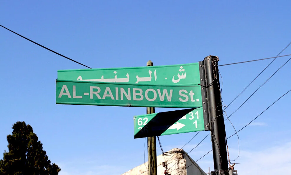
Jabal Amman, dating back to the Neolithic period and constituting the center of Amman’s 1st Circle, is the major vehicular and pedestrian east-west historic artery of the city and offers a mixed urbanity and the city’s oldest residential buildings in the Eastern Mediterranean style. The area has a grid-street network and on weekends becomes one of the city’s most congested areas. Many consider it a top priority for pedestrianization and architectural preservation, especially Rainbow Street, the main access street up the hill. It is a narrow, two-lane, one-way, local street with buildings and shops on both sides that reaches jamming traffic volumes and densities on weekends which considerably reduce its level of service especially in the evenings. The pilot was conducted over 2 years (2018-2019) to compare weekday and weekend vehicular traffic and found that the number of vehicles multiplies by a factor of 3 to 5 at weekends and that through drivers constitute more than 75% of the vehicular traffic. Photo © OHK Consultants.
Eighth, we construct emission and noise models to calculate the area’s contribution to environmental impacts. For emissions, we may use data from vehicular traffic surveys to construct a macroscopic emissions model that uses standard emission factors. Pre and after scenarios are constructed to examine several scales of interventions from part to full pedestrianization, bicycle sharing, vehicular restrictions, and different phasing of reliance on vehicular traffic. Often, however, we use portable air quality and noise handheld monitors to take microscopic readings in key intervention areas during different states of congestion and extrapolate a general understanding of the expected reduction levels.
Finally, depending on the scope of new developments that may be introduced, there may be a need for a Traffic Impact Study (TIS) to estimate impacts associated with the proposed changes. The study factors in on-site and off-site improvements and predicts the effect of changes, be it potential re-routing, pedestalization, lane strategies, or traffic signaling. The complexity of the TIS varies depending upon the complexity of the proposals.
OHK’s toolbox and its steps bring data-driven insights into our client’s problem-solving capability. Information is available in vast quantities throughout our urban and transport networks but is rarely managed and modeled in a way that adds a real advantage to organizations involved in public spaces. Without data-centered understanding, it is difficult to take a policy through to implementation and benefits realization. Our toolbox of urban and transport analytics encourages innovation in how we measure and see the problems to bring about quick insights to complex urban reform and transport issues.
For further information regarding our work in the five cities mentioned in this blog post, our client services in urban planning, transport and mobility sectors, or other areas of government support, please contact us.